

Maryland Locality Redistricting: Baltimore County's Controversial Plan
Proposal released by redistricting commission draws concerns over lack of minority representation
Welcome to the first installment in what I hope to be a series about redistricting on the local level in Maryland. Today, I will be talking about the proposed changes to the Baltimore County Council map, and the controversy that has risen from it.
First, I would like to briefly go over last decade’s map, seen below:

Under this map, Democrats have held a 4 - 3 majority through the decade, with no seats changing parties. While Baltimore County has been hit by the national suburban realignment towards Democrats, the effects have been muffled downballot, giving Republican incumbents in districts 3 and 5 a cushion as their districts have trended Democratic up-ballot.
In addition to districts 3 and 5, Republicans hold the Dundalk-based district 7 (more on that later), while Democrats hold the other four districts (1, 2, 4, and 6).
Now let’s look at the proposed new map:
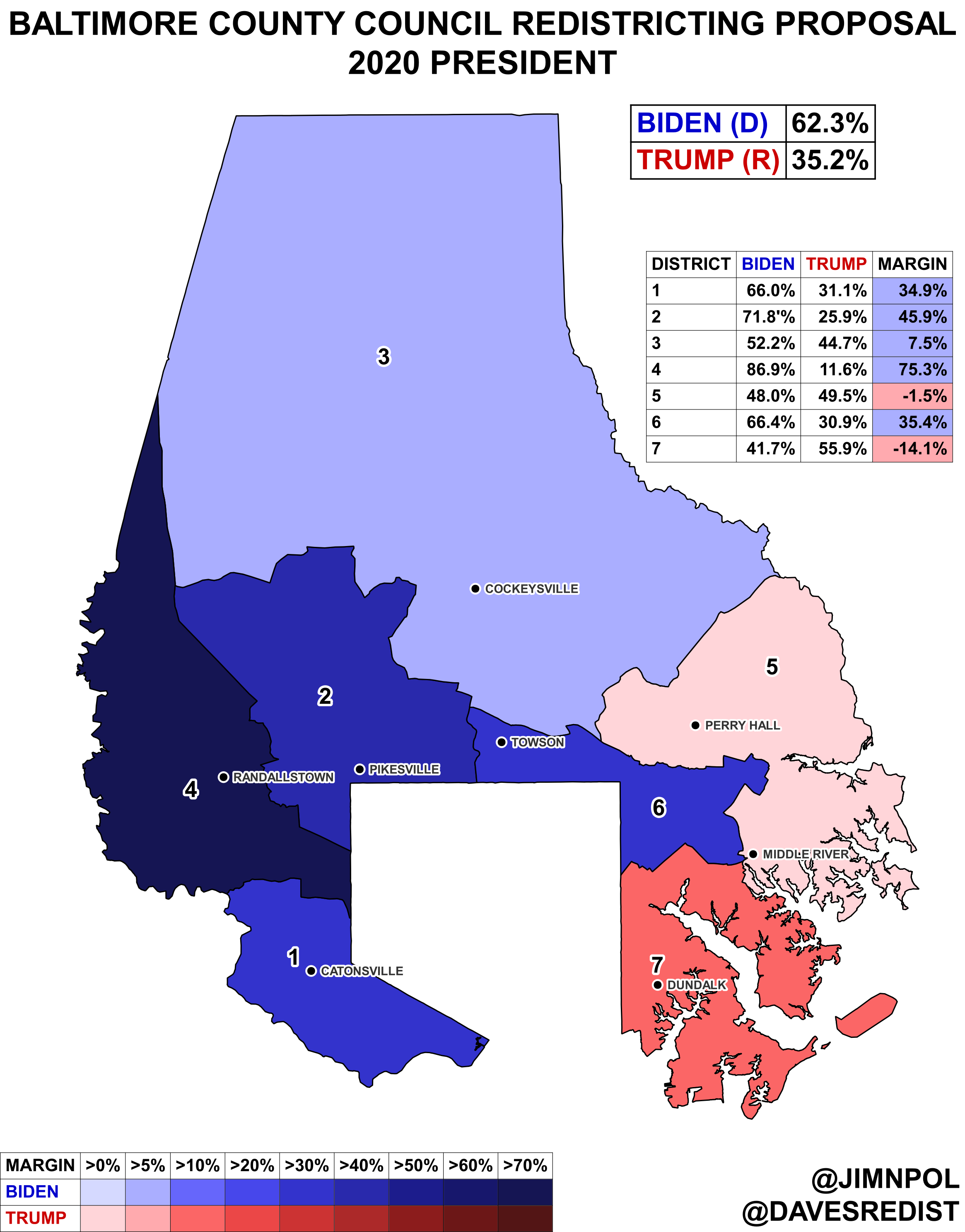
Aside from districts 5 and 6, the new map does not changes the boundaries of the districts very much.
District Overviews
District 1 (Southwest)
47.1% White
29.8% Black
13.2% Asian
8.7% Hispanic
The 1st district contains the college town of Catonsville, most of heavily-black Woodlawn, and the mostly blue collar census-designated places (CDPs) of Woodlawn, Lansdowne and Baltimore Highlands. The district contracts slightly southwards, losing a small part of Woodlawn. Incumbent Tom Quirk (D) is retiring.
District 2 (Pikesville)
51.2% White
34.7% Black
7.4% Hispanic
6.0% Asian
Hugging the northwest boundary of Baltimore city, district 2 notably includes all of Pikesville, the eastern portion of Towson, and a swath of unincoporated areas further north. In the proposed new map, the district loses a part of Reisterstown and gains more of Lochearn.
District 3 (Horse Country)
73.6% White
10.1% Black
9.1% Asian
5.7% Hispanic
Once a reliable Republican bastion, the 3rd district has changed as population in the southern part of the district has grown. While Republicans would likely be favored to hold this district for the next decade, its trend to the left makes it a tempting target for Democrats. Notable CDPs within its boundaries are Cockeysville, Timonium, and Lutherville. The proposal takes out parts of Carney, moving them into the 5th district, while taking in northern Towson.
District 4 (The Black Crescent)
73.3% Black
16.0% White
5.6% Hispanic
4.7% Asian
The 4th district includes a crescent-shaped string of majority-black CDPs, starting with Woodlawn in the south and curving northward to Owings Mills. The proposed changes remove parts of Lochearn while adding more of Woodlawn and more of the unincoprated north to the district.
District 5 (Perry Hall-Middle River)
65.9% White
17.9% Black
8.2% Asian
4.1% Hispanic
District 5 has the most dramatic change in partisan lean in the proposal. It sheds Towson and picks up fast-growing Middle River to the south, causing it to go from a district that leaned Democratic by double-digits to one that narrowly backed Donald Trump in 2020. The redrawn 5th district also puts the homes of both incumbent David Marks (R-Perry Hall) and 6th district incumbent Cathy Bevins (D-Middle River) into the same district. Were they to face off in this version of the 5th, I would give Marks the advantage, due to partisan lean and his demonstrated ability to win crossover votes.
District 6 (Towson-Parkville)
55.3% White
28.6% Black
6.2% Asian
5.8% Hispanic
Picking up most of Towson while dropping Middle River, the 6th district becomes significantly more Democratic. A new candidate would most likely run here, should this map be approved.
District 7 (Southeast)
65.9% White
17.7% Black
9.0% Hispanic
2.1% Asian
While district 7 was a Democratic stronghold around a decade ago, its high proportion of non-college whites has translated into a strong shift towards Republicans in recent years, making this district unlikely to be competitive. The only change from redistricting was that it gained a small portion of Rosedale.
Potential for Changes
With a white population of only 51.8 percent, some Baltimore County residents have raised concerns over the fact the proposed map has only one majority-black district. Below, I drew a map that makes the 2nd district majority black, while changing the other districts as little as possible:

That’s all for now. I’ll release another in this series when I can.